

Detecting Emissions Using Flyover Technology
Companies regularly leverage flyover technology as part of their commitment to identifying and reducing methane emissions. Flyover technology measures methane emissions from oil and gas operations using a methane-specific light detection and ranging (LiDAR) instrument, which is mounted on low-flying fixed wing aircraft and offers high-resolution mapping of methane emissions across a wide area of coverage.
Over the past two years, companies participated in flyovers in eight basins (Permian, DJ, Bakken, Marcellus, Anadarko, Eagleford, Haynesville and Powder River), and surveyed nearly 10,000 sites. In many cases, operators surveyed their more complex sites and, in each round of surveys, chose different sites, thereby providing a deeper understanding of emissions across their assets.1 Such flyovers provided key areas of learning, including: (1) the opportunity to deploy and understand the capabilities of new aerial detection technology and (2) the ability to advance understanding of methane emissions profiles, including source identification and approximate rates, through collected data across a mix of operations.
ALL OPERATORS – ALL BASINS | 2022 PHASE II
|
|
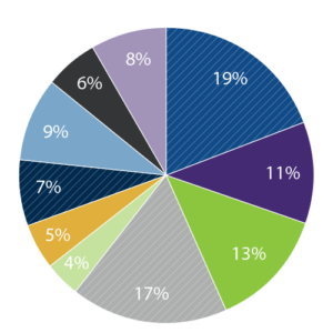 |








Operators found that the flyover technology provided an aerial snapshot in time of methane emissions selective with high enough resolution to attribute such emissions to a single piece of equipment in the field. The results indicate tanks, compressor-driver packages and flares were the primary sources of methane emissions on a volume basis.
Results also found that in the production segment, emissions from compressor driver packages detected by aerial technology differed from follow-up ground level optical gas imaging (OGI) camera surveys. We followed up on these findings to better understand the emission sources of methane from compressors and their drivers and identify the compressor package components responsible for observed emissions.
In conjunction with the aerial surveys, companies participated in a study by Colorado State University to validate the methane specificity of the LiDAR instrument and to conduct controlled release experiments to validate flux calculation accuracy. These results, published in a peer reviewed scientific journal in November 20222, demonstrated minimal interference from other hydrocarbons including CO2 commonly found in natural gas, reducing risks of inaccurate measurements.
The aerial surveys allowed a range of operators – from those with only a handful of wells or compressor stations to major companies – to cost-effectively explore a new detection technology and to better understand their methane emissions. Moving forward, participating companies are now able to make more informed decisions on appropriate measurement and monitoring strategies for their organizations, including the use of aerial detection, in their efforts to reduce emissions. The surveys accelerated industry adoption of alternative monitoring technology and helped to prioritize The Environmental Partnership’s future work towards identifying solutions for primary sources of methane emissions.